Table of Contents
What to Expect From Wisconsin UTV Trails
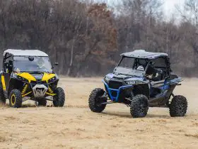
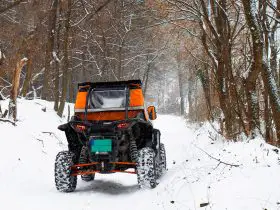
There is an unprecedented number of UTV ready trails located throughout the state of Wisconsin. Many are on county trail systems that run past lakes and through forest parks. You can find almost any kind of terrain and landscape from rushing rivers to wide open spaces and rugged mountains.
Some locations have specific requirements and only allow certain types of vehicles. You will want to check before choosing a particular trail system to make sure that you will be able to follow local regulations. You also want to familiarize yourself with the Wisconsin laws regarding riding UTVs. You can find that information on the Wisconsin Department of Natural Resources website (https://dnr.wisconsin.gov/topic/atv).
The Best Trail Systems in Wisconsin for Side-by-Sides
We have found the best trails for UTV riders in the state of Wisconsin and have put together brief descriptions of each, including need-to-know location information and what areas are nearby.
Washburn County Trail System
https://www.co.washburn.wi.us/departments/forestry/atv
Size: 103 miles
Area: Washburn County
Terrain: Forest trails
Details: This system of UTV-ready trails branch off of the Wild River Trail, which is an abandoned area of a railroad. They are all open for ATV and UTV use, but motorcycles and dirt bikes are not allowed.
Yearly Closures: The trail is closed to UTVs anytime the Department of Natural Resources (DNR) puts out a fire hazard warning. It is also closed between April 1st and May 31st.
Douglas County Trail System
https://www.douglascountywi.org/244/Recreational-Trails
Size: 1,200 miles of trails with 300 miles that are maintained throughout the year
Area: Douglas County
Terrain: Forest trails
Details: This trail system winds through the Douglas County forest, which is one of the largest in the entire state. It has areas that are well maintained year-round so that you can enjoy UTV fun there in the winter or summer. Motorcycles and smaller recreational vehicles are not allowed without express permission from the Forestry Department. For additional information, you are encouraged to contact the Douglas County Forestry Department.
Yearly Closures: The trail system is closed to vehicle traffic during the spring to protect against ground erosion and accidental fire. It is also closed whenever the DNR puts up a red flag fire hazard warning for the area.
Iron County Trail System
https://www.ironcountyforest.org/atv-utv-trails.html
Size: 118 miles
Area: Iron County
Terrain: Mostly forest trails
Details: Riders are required to stay on marked trails. There are signs marking them, and they are maintained year-round. One of the trailheads is Schomberg Park, which has a campground you can use as a basecamp.
Yearly Closures: The area is closed to vehicle traffic between March 31st and Mid-May. It is also closed during DNR high fire hazard warning periods.
Price County Trail Systems
https://co.price.wi.us/410/ATV-UTV-Off-Road-Motorcycling
Trail systems:
- Flambeau Trail System (https://www.pricecountywi.net/423/Flambeau-Trail-System)
- Solberg Trail (https://www.pricecountywi.net/432/Solberg-Trail)
- Tuscobia State Trail (https://www.pricecountywi.net/433/Tuscobia-State-Trail)
- Georgetown Trail (https://www.pricecountywi.net/425/Georgetown-Trail)
- Flambeau River State Forest Trail (https://www.pricecountywi.net/419/Flambeau-River-State-Forest-Trail)
Size:
- Flambeau Trail System (70 miles)
- Solberg Trail (9.5 miles)
- Tuscobia State Trail (74 miles)
- Georgetown Trail (15.8 miles)
- Flambeau River State Forest Trail (70 miles)
Area: Price County
Terrain: Forest and lake trails
Details: Primarily located in the Price County Forest these trail systems cover a lot of topography. Georgetown Trail goes through some local community areas while the Solberg Trail is located near several substantial lakes. These trails are maintained throughout the year, and they come in various lengths, so if you want to take your whole family out, you can enjoy a nice day trip, or you can go for a multi-day ride on some of the more extensive trails. For more information on each route, you can check out the Price County website.
Yearly Closures: All locations are closed to vehicles when DNR fire hazards are listed.
- Flambeau Trail System is open between May 1st and March 14th
- Solberg Trail is open between May 1st and March 14th
- Tuscobia State Trail (Price County section) is open between April 16th and November 14th
- Georgetown Trail is open between May 15th and March 14th
- Flambeau River State Forest Trail is open between May 15th and November 15th
Cheese Country Trail System
https://www.lafayettecountywi.org/trails
Size: 47 miles
Area: Lafayette County
Terrain: Forest, lake, and surrounding communities
Details: This is an excellent trail system if you love to explore area history while having fun outdoors. Many of the trails lead to local areas like Mineral Point, which is an artisan community. Shopping, lodging, and restaurants can be found at various places along the route. It is an excellent option for anyone who wants to spend the morning riding through nature reserves, followed by a relaxing evening on the town.
Yearly Closures: The system is closed when the DNR fire hazard is in the red. Exact yearly closure dates are not listed, but you can reach out to Deb Krahenbuhl, the Lafayette Cheese Country Trail Liaison, for more information at the email info@tricountytrails.com
Clarke County Trail System
https://www.clarkcountywi.com/for-trails-atv
Size: 135 miles
Area: Clarke County
Terrain: Mainly forest trails
Details: There are posted trails in this system for UTVs, and you will need to stick to them. The trail boasts five camping areas and has access to the following.
- Parking areas
- Loading ramps
- Day-use areas
- Fuel
- Food
Yearly Closures: Closed during times of DNR high fire hazard, also closed November 1st to December 14th and March 16th to May 14th.
Riverview ATV Park
https://www.visitkewauneecounty.com/explore/parks-and-trails/riverview-atv-park/
Size: Over 20 miles
Area: Kewaunee, WI
Terrain: Forest and park trails
Details: No pets are allowed at this location. They have a restroom, picnic tables, parking, and access to various trails in the area. It is a lovely forested area and is fantastic for a fun day ride. For information on the trail or closures, you can reach out to their 24/7 Promotion and Recreation Hotline at (920) 388-7199
Yearly Closures: Closed between November and May.
Oconto County Trail System
https://www.ocontocounty.org/visit-us/trails/
Size: 450 miles
Area: Oconto County
Terrain: Mix of open, lush locations and forest trails
Details: You will need to have a non-resident or Wisconsin UTV pass on your vehicle to use this trail system lawfully. You can get a 5-day non-resident pass for $20. This trail system features gorgeous wide open and forest views and is located a few hours from Milwaukee.
Yearly Closures: You can reach out to Oconto County Tourism for information on closures and trail passes at 1-888-626-6862.
Chippewa County Trail System
Size: 23 miles
Area: Chippewa County
Terrain: Hills, valleys, forests, lake, and twisting trails
Details: The beautiful landscape in Chippewa County comes in all varieties. There are lakes, rivers, steep mountain hills, and winding trails leading down into open valleys. A truly picturesque experience. There are designated trails, and wandering off of them can get you fined $100 – $500, so keep a close eye on the signs.
Yearly Closures: The trail is closed between November 15th and May 1st.
Dead Horse Run Trail
https://www.fs.usda.gov/recarea/cnnf/recarea/?recid=27745
Size: 63
Terrain: Heavy forest and hills
Details: This trail is more challenging than some others, and the Forestry Service recommends that you bring tools in case you get stuck. There are also minimal options for purchasing fuel at the location, so you will want to make sure to bring extra with you. There are areas of the trail where mud or water may make traversing it more difficult. If you are planning to really rough it outdoors, this is the trail system for you. This trail system begins at the Camp Loretta Trailhead, and some trails only have a clearance of 14 inches, so you will want to make sure you plan out UTV friendly only sections before heading out. It does go through a few local communities. For information about the trail, you can reach out to the Great Divide Ranger District. Their contact information is on the United States Department of Agriculture and Forest Service website (Read more at fs.usda.gov).
Yearly Closures: Check for closures related to weather as they close these trails during bad storms and times of high fire danger. Otherwise, no specific dates are listed online, so you will want to reach out to the Great Divide Ranger District or check online to see if they are open.
Summary
There are trails for everyone in Wisconsin. Whether you want to go out for a day trip with your family or a weekend solo ride through some challenging terrain, there are trail systems to satisfy your desires. This is a gorgeous state with some amazing forest, river, lake, and valley trails that will allow you to connect with nature while enjoying what the local communities have to offer.
When in doubt, always reach out to the local forestry service or county for more information about possible closures, changes due to Covid-19, and nearby accommodations. Also, be sure to brush up on the Wisconsin state laws and local community regulations before heading out with your side-by-side. Some areas require a pass to drive through, and others are strict about which trails UTVs can operate on, so check for that ahead of time. The best way to get the most out of your trip is to know what to expect from the trails and make sure you are fully prepared for any eventuality.


